Showing posts with label Hasa. Show all posts

Friday, November 29, 2013

Qatif & The Arabian Gulf in European Maps: from the Renaissance to the Cold War

'No arms of the sea has been, or is of greater interest, alike to the geologist and archaeologist, the historian and geographer, the merchant, the statesman, and the student of strategy, than the inland water known as the Persian Gulf.
Sir Arnold Wilson, 1928

The oasis of Qatif in the east of modern Saudi Arabia has always maintained geo-political prominence for thousands of years. The following collection of maps manifests how changes in the geopolitical landscape of the region influenced the limits and dominance of "Historical Qatif" after the medieval period, and the emergence of Ottoman imperial power. In particular, the collection starts with  the Arabian gulf as viewed from the perspective of Renaissance Europe, along with rise of the Industrial Revolution all the way to Colonial Europe and the end of World War II and beginning of the Cold War.

1598
Qatif is repeated as the town “Catiffa” and the region “Elcatif.”. This map was published in 1598 by Flemish cartographer Jodocus Hondius (1563-1612). (source)
1602
A miniature map of the Persian Gulf published in 1602, from the first set of plates used to illustrate Bertius's 'Tabularum Geographicarum Contractarum'. Qatif appears as "Catiffa" (source).
1603
A miniature map of Arabia, an example of the first plate, without longitude or latitude scales. Map by BERTIUS, Petrus was published in Amsterdam in1603. Qatif appears as "Catiffa" and "ElCatif" (source).

1606
Map by Petrus Bertius Published Amsterdam 1606 by Cornelium Nicolai, in; "Tabularum Geographicarum Contractarum Libri Quinque". Qatif appears as "Catiffa". (source)
1610
A scarce map of Arabia, engraved by Heinrich Gross jnr. for a German edition of the travels of Ludovico di Varthema (or Barthema, c. 1470-1517), the first non-Muslim European to enter Mecca as a pilgrim. Qatif is mentioned as "Catiffa" and "Elcatif" (source).

A scarce map of the Persian Gulf, marking 'Barem', engraved by Heinrich Gross jnr. for a German edition of the travels of Ludovico di Varthema (or Barthema, c. 1470-1517). Qatif is mentioned as "Catiffa" (source).

1612
Barent Langenes map of the Straits of Hormuz first issued in his Caert-Thresoor and later re-published by Bertius in his Tabularum Geographicarum, beginning in 1600. Qatif apears as "Catiffa". This map was published in Amsterdam in 1612 (source)

1625
Hondius’ Map of the Turkish Empire from Samuel Purchas, Hakluytus Posthumus or Purchas His Pilgrimes, London 1625. The Arcadian Library (source). The map clearly labels the Arabian-Persian Gulf as "Mare elcatif"
1633
This map is from the 1633 German edition of the famous Mercator-Hondius Atlas. The cartography is largely based on the Ortelius map of 1570 which in turn drew on an earlier map by the Venetian geographer Jacobo Gastaldi (1500-1566).  The map labels the gulf as "Sinus Arabicus" or Arabian Gulf and identifies it as "Mare Elcatif", meaning the Sea of Al-Qatif. This map often cited as "historical evidence" of the use of the name Arabian Gulf (source).

1654
17th Century French Cartographer Nicolas Sanson created this map in 1654 in Paris. Qatif maked as "Cattif" in region of Bahrain (referred to as "Bahraim"), bordering the Arabian gulf named as "Mer d'El Cattif". The borders of the region resemble that of the Ottoman Lahsa Eyalet. (more can be found in this source).
source
1658
The town of Katife, ElCatif Desertum, and The Arabian Gulf is called “Mare elcatif olim Sinus Persicus” (Al Qatif Sea formerly known as the Persian Gulf). The map was published by the Dutch cartographer Johannes Janssonius (1588-1664), or Jan Jansson in 1658. (source). A very similar map can be found here.

1675


Qatif is clearly marked as the town of "Catifa", and the Arabian Gulf is called “Mare Elcatif ol Sinus Persicus” (Al Qatif, Persian Gulf). This portolan map by the Dutch engraver, publisher, and map seller Frederick de Wit in 1675. (source)
1707
Qatif is labeled as "El-Catif", and the map gives three names for Al Ahsa: “Ahsa,” “Labsa,” and “Lessa.” This 1707 map of the Arabian Peninsula and adjacent regions is the work of Dutch publisher Pieter van der Aa (1659-1733). (source).
1721
Qatif is marked as "El Catif", Al Hasa is labled as "El Ahsa" in this 1721 map by French mapmaker Guillaume de L’Isle. (source).
1740
Qatif is marked as "Al Katif", with the largest font of all cities around the Arabian Gulf. This 1740 map is by the French cartographer and hydrographer Jacques-Nicolas Bellin (1703-72). (source). A similar but colored map can be viewed here.

1745

Cropped section of German version of Jacques-Nicolas Bellin's engraved map of Arabia showing "Al Katif" (source).

1749
French map drafted by Robert de Vaugoudy. Qatif appears as "El Catif" and "Tarout" (source).

1774
Map published in Amsterdam by S.J. Baalde and Utrecht by J. van Schoonhoven & comp., 1774. (source)

1805


Map published in 1805, where Qatif is mentioned as "el Katiff". (source)

1835
This is one of the first American maps of the Arabian Gulf. Qatif is marked as "Katif", Tarout Island is labeled "Taroot", and Al-Hasa as "Lahsa". This 1835 map was made by Thomas Gamaliel Bradford, a Bostonian of a distinguished New England family. (source).
1842
The town of Qatif, labeled as "elKatif", is marked as the largest and most signficant city on the Arabian gulf. Also clearly marked is the peninsula of Ras Tannurah, the city of Hofuf as in "el Hofhuf" and Al-Hasa as in "El Hassa". This map defines the region of "El Katif" as extending from Half Moon Bay south of Dhahran all the way to Ras Al-Khair (Also called Ras Al-Zour, Ras Azzour) labeled as "Ras el-Ghas". This map was published in Paris in 1842 by French cartographer and engraver Pierre M. Lapie. (Source).
1848
Qatif town labeled as "el Katif", Saihat as "Seihat", Ras Tannurah and Djilla Assagn all included in the region of "el Katif". This 1848 map was made by by the French cartographer and engraver Pierre M. Lapie. (source).
1852
This 1852 map from the New Universal Atlas (USA) by the Philadelphia publisher Thomas, Cowperthwait & Co. show the town and Bay of Qatif as "ElKatif", "El Katif", along with Tarout as "Taroot", and Al-Hasa as Lasha. (source). Another 1864 map can be found here.  
1855
The map was published by J.H. Colton, New York in 1855. Showing Qatif as "El Katif". (source).

1866
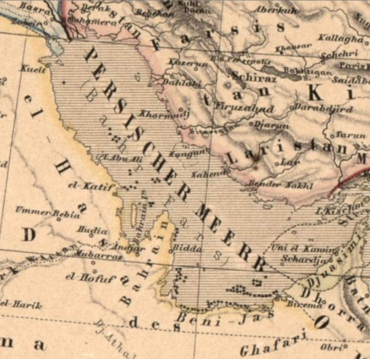
The map was issued by the Geographical Institute of Weimar in 1866. Showing Qatif as "El-Katif" and the city of Kuwait as in "Kueit". (source).

1868
Samuel Augustus Mitchell (1792–1868) was a renowned American geographer and cartographer, who published this map in 1868, marking Qatif as "ElKatif". (source)
1871
This map appeared in William Gifford Palgrave's book: "Personal Narrative of A Year's Journey Through Central and Eastern Arabia (1862-63), published in 1871. The map engraved by J. Sulzer, Berlin, and published by Macmillan & Convent Garden, London in 1865. (source)

1885
This 1885 map by British London publisher Edward Stanford shows the region of Qatif under Ottoman territory marked all the way to Half Moon Bay south of Dhahran. The city of Qatif, labaled as "El Katiff", is connected to four different major routes, leading to Ha'il (home of Shammar), Diriyah, Al-Buraimi (in Oman) and Basra in the north.  The map also marks Ras Tanoora, and Tarout Island, labeled as "Terhat". Also, this is the first map that mentions Daman island, which is most likely associated with the settlement of Dammam (source). A similar map can be found here.
1891
This map of the Ottoman Vilayet of Basra (published by Gotha: Justus Perthes) shows the road routes in the former region of Lahsa Eyalet from Basra all the way to  the main Gulf coastal city of Qatif (El Katif)  passing through Kasima (Kadhima or Kazema) and Kuwait (Koeit) (Source: Adolf Stielers Handatlas).


1900's
Map by Edward Stanford, London nd ca 1900. Cover title: London Atlas Map of Persia. Qatif appears in the bottom of the map as "El Katiff" (source).
British map published by missionary and professor at Princeton University, Dr. Samuel Marinus Zwemer in 1900 in his book "Arabia: The Cradle of Islam". (Source)

This map was made at the beginning of the 20th century by Gustav Freytag. Highlighted here are el-Katif (Qatif), Tarut (Tarout), Ras Tannura (Ras Tanura) and Thahran (Dhahran). (source)
1922
Map of Arabia showing "El Katif" (source).

1922
Map of Arabia showing Qatif. Henry William Mardon - Encyclopædia Britannica, v. 30, 1922, p. 164 (source).

1926
Map of Arabia from The History of the Arabian Mission by Alfred Mason and Frederick Barney, 1926 (source).

1949
A 1949 map showing Queyt (Kuwait), Katif (Qatif), Bahreyn (Bahrain) and Hofuf (Hofhuf) as the only major cities in the eastern coast of Arabia. The whole region is defined as Hasa and Katif. (source).

1955
This map of the Middle East, originally published in August 1950 and revised in February 1955, was issued by the Aeronautical Chart and Information Center, Air Photographic and Charting Service, Military Air Transportation Service (MATS), of the United States Air Force. The map is one of the first ones using the standardized latin name for Qatif. (source)

It is very evident that Qatif remained to be the most prominent coastal town in Eastern Arabia, despite the wide variety of spellings used ( ranging from Catifa, Catiffa, Katif, ELKatif, Kateef , Katyf, Katiff, Katiffe, Qateef, El Katiff, Qaif, El Quatiff, Khatif, Cattif,  Catif, Katife, ElCatif, Cateef, Kutiffe, Kuteef, Khatif, ElKhatif to EL Cattif).

Wednesday, November 27, 2013

Qatif in the 21st Century: An Ongoing Struggle with Urban Encroachment

"The Qatif oasis one of the largest settlements in Saudi Arabia, rivaled in size only by the inland oasis of Al Ahsa", remarked the great world scholar of geography Charles H. Ebert, distinguished professor at the University at Buffalo in an article published in 1965 by the American Geographical Society (source). In his valuable article, Ebert provides a detailed description of the Al-Qatif region and it's geographical limits and topographical landmarks.  He describes Qatif as
"The region is the most intensely utilized irrigated land along the Saudi Arabian coast of the Persian Gulf. The relative ease with which abundant water can be obtained from the aquifers coupled with the availability of a sizable area of level land provides a partial explanation for the notable role this region has come to play as the leading coastal oasis of the Eastern Province."
The Qatif Region as highlighted in Professor Charles Ebert's 1965 article published in the Journal of Geographical Review by the American Geographical Society (source). He specifically indicated that Qatif's influence extends from Jubail in the north all the way to Abqaiq in the south.
He was particularly concerned with the highlighting the risks and solutions to the potential problems surrounding the oasis. He mentioned that
"A clear need exists for a long-range water-conservation policy."
In addition to all the provided detailed recommendations he suggested in the article, professor Ebert emphasized that his suggestions should be implemented in a way to "ensure the smallest amount of communal upset and dislocation in the way of life of the people of Qatif, a factor that should not be underrated".

A colored picture taken in 1952 showing the Hammam of Tarout in Tarout Island. The picture summarizes the "the way of life of the people of Qatif" that professor Ebert was concerned with preserving. (source)
Professor Ebert also emphasized encroachment as an imminent threat to the ancient oasis, highlighting that
"Although time seems to stand still in the quiet palm gardens of Al Qatif, the proximity of rapidly growing administrative and commercial centers cannot be overlooked. One of these is the port town of Al Khobar, near Dhahran, which has grown into an important commercial center that reflects the increasing demand for shopping and other service facilities for the people associated with the nearby oil industry. Other rapidly growing towns are Dammam, capital of the Eastern Province, Safwa and Al Jubail, and the Aramco centers of Dhahran, Abqaiq, and Ras Tanura. These growing settlements, and their increasing requirements for foodstuffs, will place an ever greater demand on the production capacity of Qatif's agriculture".
The growing small settlements and towns that professor Ebert mentioned in his article grew exponentially to become one of the most heavily urbanized areas of Saudi Arabia, as seen below.
The modern Qatif Oasis is under the menace of urban encroachment, as it is situated at the heart of the Eastern Province conurbation of of Khobar-Dhahran-Dammam-Ras Tanura all the way to Jubail.
In the closing of his article, professor Ebert warned that problems of encroachment and water-conservation "must be overcome if the soils, and thereby Qatif itself, are to be saved from eventual destruction". Such warnings were never widely publicized, and therefore failed to resonate among the people of the Eastern province, and in particular the people of Qatif, to whom Ebert made particular reference.
However, Ebert emphasized that it is the responsibility of the authorities in Qatif to legislate and implement policies in favor of his suggestions. The reality of Qatif's "green landscape" seen from the aerial view below reflects the failure of the Eastern Province's authorities and Saudi Arabian government in ensuring the preservation of a vibrant "oasis lifestyle" which has been completely lost as a result of urban encroachment and lack of a water-conservation program.

The green-landscape of the Qatif Oasis has been effectively reduced to narrow areas that are increasingly depleted due to negligence and urban encroachment.
Since the beginning of the 21st century, public awareness of environmental hazards has increased exponentially, especially with the spread of the internet and rise of social media within Qatif. However, despite such environmental activism and public awareness campaigns, the influence of urban encroachment remains the greatest threat on the surviving agricultural areas of the Qatif Oasis. The below images, which compare changes in the area between 2005 & 2012, provide significant evidence on the scale and growing rate of urban encroachment in Qatif.

Professor Charles Ebert recommended that "part of the oasis land" should be allocated "to deep, effective drainage channels" so that Qatif can "be saved from eventual destruction".
Let's look at what happened to the existing ancient drainage channels, re-built by the Ottomans, between 2005 and 2012.

The ancient drainage channel network, re-built by the Ottomans, were systematically buried in the first decade of the 21st century. This picture is for the channel beside what used to be the factories of Al Matrood Dairy Company, now named to UND (United National Dairy Company).

Urban Encroachment around the agricutlural lands between Saihat and Anak.


Urban Encroachment around the agricutlural lands between Saihat and Anak.

Urban Encroachment around the agricutlural lands between Saihat and Anak.
In 1965, Professor Ebert was very optimistic that "indications are that the people, encouraged by visible success, will follow the new ways that will ensure the continuity of their existence. " However, the sad reality, confirmed by the following satellite images, confirm that the people of Qatif are still actively participating in the reduction of agricultural lands, supported by the Eastern province authorities and the government of Saudi arabia.

The expansion of Al-Qudaih village came at the expense of agricultural lands.
The reduction in agricultural lands between the towns of Al-Qudaih and Al-Awamiyah.

The rural areas around Al-Awamiyah has been subject to urban encorachment from 2005 to 2012.

The rural and agricultural lands around the city of Safwa also suffered urban encroachment between 2005 & 2012.
The Saudi government has actively destroyed all the rural areas of Qatif, including the site of the ancient spring of Ain al kaaba around the Al-Jish village, which was built a thousand years ago by the Qarmatians. This picture is not exactly for the spring, but for the surrounding area.

Notice the reduction and desertification of green-lands.


Loss of agricultural land in the center.


The villages of Al-Mallahah, Umm Al-Hammam and Al-Jish increased their urban area at the expense of agricultural land.

While areas from land-reclamation projects have remained absent of any urbanization due to corruption issues, the agricultural lands became the only alternative for building urban dwellings.

Changes in agricultural lands around the Al-Khuwaildiyah village from 2005 to 2012.

Changes in agricultural lands south of the town of Al-Qudaih from 2005 to 2012.
Urbanization in rural areas.

Agricultural lands turned into urban dwellings around Al-Riyadh street in the village of Al-Jaroudiya.

Little remains of the agricultural lands around the city of Qatif. This image is for the areas south of al-Majidiah commercial & Warehouses area.

Even  the village of Halat Mahish was affected. 

Urbanization in Al-Jaroudiya is taking place at the expense of agricultural land.

Agricultural lands between Saihat and Anak.
Negligence of green areas has resulted in them being converted to barren lands, as clearly marked in the top of the images.


Rural areas around Al-Mallaha village. 

Additional evidence of urban encorachment.
Negligence has reduced most of  the green areas to barren lands.

The area of Qatif's ancient Fortified City and the surrounding palm-tree forests have been converted to urban areas.

Evidently, there exists a desperate need for a well-organized public campaign to push the government to legislate laws and policies for the protection of the surviving agricultural lands of the Qatif Oasis.  In particular, the government of Saudi Arabia should allocate a reasonable part of the green areas as a national sanctuary and a natural reserve. A protected area of the Qatif oasis would preserve the unique wildlife, flora, fauna and geographical features, and would help ensure the systematic conservation of the oasis, providing an ideal environment for study and research.