This Map dating to 1758 is by French Cartographer Jean Baptiste Bourguignon d'Anville during the reign of Louis XV. The map is based on what is known in France during the times of the Ancien Régime. European knowledge of the Arabian Gulf is primarily based on the Portuguese colonization of the region.
http://www.geographicus.com/P/AntiqueMap/PersianGulf-anville-1776
The following can be observed from the map.
http://www.geographicus.com/P/AntiqueMap/PersianGulf-anville-1776
The following can be observed from the map.
- The city of Qatif is markedly identified as "El Katif"
- Notice how the name Kuwait doesn't appear in the map, confirming the later foundation of the city-state in the latter part of the 18th century.
- The island of Failaka is clearly marked. Though it consists of a small population in the modern times, the island formed strong historical/cultural ties with the oases of Qatif, Hasa and the island of Bahrain. Such ties date back to the civilization of Dilmun in the ancient times.
- The entire peninsula of Qatar is absent, indicating the lack of strategic importance, limited sphere of influence, and small population.
- Only a number of towns are named in the lands ruled now by the United Arab Emirates.
http://www.geographicus.com/P/AntiqueMap/PersianGulf-sales-1770
 g
g
The following can be observed:
The growth and expansion of Western interests in the Indian Ocean (namely the Rule of the British East India Company, 1760's to 1850's), along with the successful Egyptian campaign through Arabia, both increased western knowledge of the Arabian Gulf.
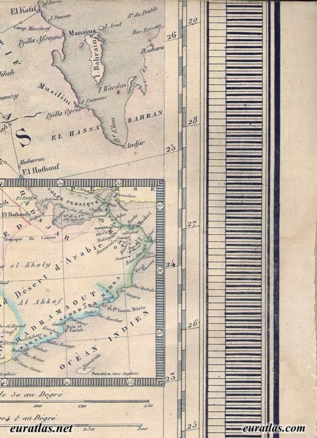
This map, dating back to 1845.
http://www.euratlas.net/cartogra/ottoman_1845/images/ottoman_12_7.jpg
This map, dating back to 1845.
http://www.euratlas.net/cartogra/ottoman_1845/images/ottoman_12_7.jpg
The following can be observed:
- A much more accurate description of the shores of the gulf.
- Tarout Island is correctly drawn at the heart of the Tarout Bay.
- Half-Moon Bay is accurately mapped.
- Roads leading to Qatif & Hoffuf are marked with stops.
- This is evidence that the Egyptian campaign must have influenced the knowledge of the roads leading to these oases.
- The appearance of clear demarcation of Qatar and other towns in the region is indicative of the change in the political landscape during the last century (1750 to 1840). Political changes include
- The rise of the Wahabbi-Saudi alliance, and expansion in their dominion.
- The influx of powerful Najdi Arabian tribes in the middle of the 18th century to the shores of the Gulf, eagerly stepping into the power vacuum that resulted from the waning Persian Safavid Empire.
- Namely, the migration of the descendants of the Bani Utbah tribe which started in 1744, the same year in which Muhammad ibn ʿAbd al-Wahhab concluded a pact with Muhammad bin Saud, marking the beginning of the Wahhabi movement.
- The contemporary ruling monarchs in Kuwait and Bahrain (who notably rejected Wahhabism) are the most notable descendants of the migration of Bani Utbah.
- This migration changed the political and the social fabric of the region. Marking the start of the continuing decline of the oases of Qatif and Hasa, and their sphere of influence in the Arabian Gulf.
No comments:
Post a Comment